StationMap
Introduction
A special feature in CumulusUtils is the possibility to display the location of the station on a zoomed in map. The map can display the winddirection (updates with realtime.txt) and a windrose for the indication of the North direction. As the zoom factor can be quite large (try 16 or 17) this map gives an interesting possibility to show live wind influence in harbours or airfields (which is where the inspiration came from, see this post). The Wairoa airport which inspired this function is here.
NOTE: this map displays the wind speed and direction from live data. Because of this it can not be used as a module as it depends on the javascript runtime system which is not present in the modular usage.
Inifile parameters
The StationMap has the following inifile parameters:
   [StationMap]
   StationMapMenu=true
   ArrowLatitude=53.2948
   ArrowLongitude=7.0673
   Zoomlevel=13
   CompassRosePosition=bottomright
   CompassRoseType=2
   WindArrowType=1
Inner Working
The Position of the Compass Rose/arrow combination and the zoom factor can be set by the user. Parameters ArrowLatitude, ArrowLongitude and zoomlevel in the section [StationMap]. The map will centre halfway the wind arrow and the station marker.
The map is created with the leaflet library with the zoomlevel as found in the inifile. A larger zoomlevel zooms in, a smaller zoomlevel zooms out. A little experimentation should give what you want.
The WindRose is created from the image CompassRose-{x} where x is the value of CompassRoseType. If the user adds images with the same naming convention it is possible to add different CompassRoses to the map by changing the CompassRoseType. The CompassRosePosition has the possible values of: topleft, topright (default), bottomleft or bottomright.
The WindArrow is created from the image WindArrow-{x} and can be placed at a position other than the station position which is taken as the default for the arrow position. If the user adds images with the same naming convention it is possible to add different WindArrows to the map by changing WindArrowType.
If StationMapMenu=false then the module will not be generated and the menu entry for the website will not be made.
Images used
The images are located in the CUicons directory. If you want other images, just add them with the required index.

CompassRose-1.png
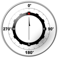
CompassRose-2.png

CompassRose-3.png

WindArrow-1.png


