Pressure Measurement: Difference between revisions
m (→Datum: Note added re METAR) |
|||
| Line 20: | Line 20: | ||
==Datum== |
==Datum== |
||
Pressure decreases exponentially with altitude, so for consistency it is reduced to the common datum of mean sea level (MSL). |
Pressure decreases exponentially with altitude, so for consistency officially it is reduced to the common datum of mean sea level (MSL). You can see those figures on the isobar lines of a weather map. |
||
''A note of caution - if you are looking at an external site and using the pressure there to compare with your personal weather station, check whether what you see there is corrected to sea level.'' A widely used template on amateur sites that reports barometric pressure taken from "METAR" issued by airports does not differentiate between altimeter pressure (at field elevation level in pilot terms - QFE) and sea level pressure (at nautical height in pilot speak - QNH), and it is normal for all airports following North America guidance to report the former in the standard METAR Pressure Group. |
|||
==Setting the Datum== |
==Setting the Datum== |
||
Revision as of 12:40, 16 February 2018
Atmospheric pressure (also known as barometric pressure) is the pressure exerted by the weight of the air above the Earth's surface. It is measured using a barometer. Atmospheric pressure and its rate of change are important parameters for weather and the ocean.
Locating the Barometer
For most personal weather stations, the barometer is in the console, usually attached to the printed circuit board. These barometers are very cheap devices that simply record the load on a diaphragm. Unlike the barometer in an automatic weather station, they have no temperature compensation. Therefore, for best pressure readings, you should locate the console in a place where the temperature is reasonably constant, not in direct sunlight or near a heater.
Units
The units most often used by meterorologists in much of the world for atmospheric pressure are hPa (hecto Pascals, although not a System International unit because of its prefix).
Alternatives units are
- mb (millibars, this is the equivalent used for public communications, but its scientific definition has varied from 101,325 Pa to (from 1982) 100,000 Pa),
- mmHg (millimetres of mercury, strictly a function of temperature and gravitational force as well as atmospheric pressure, abandoned in 1929),
- torr (now defined as exactly 1/760 of a standard atmosphere, almost equivalent to mmHg, but mmHg varies by temperature and gravitational strength),
- kPa (kiloPascals is a SI unit, used in Canada),
- inHg (inches of mercury, used in USA and by some UK instruments, but strictly a function of temperature and gravitational force as well as atmospheric pressure).
Cumulus supports:
- 0 = mb (millibars)
- 1 = hPa (hectoPascals)
- 2 = in (inches of mercury)
Datum
Pressure decreases exponentially with altitude, so for consistency officially it is reduced to the common datum of mean sea level (MSL). You can see those figures on the isobar lines of a weather map.
A note of caution - if you are looking at an external site and using the pressure there to compare with your personal weather station, check whether what you see there is corrected to sea level. A widely used template on amateur sites that reports barometric pressure taken from "METAR" issued by airports does not differentiate between altimeter pressure (at field elevation level in pilot terms - QFE) and sea level pressure (at nautical height in pilot speak - QNH), and it is normal for all airports following North America guidance to report the former in the standard METAR Pressure Group.
Setting the Datum
All weather stations allow you to adjust the pressure for sea level. You should not make the adjustment within Cumulus. For Fine Offset see FAQ#Cumulus_doesn.E2.80.99t_show_the_same_pressure_as_my_Fine_Offset_console. On a Fine Offset station, the pressure measured at the station is called Absolute Pressure, and the pressure corrected to sea level is called Relative Pressure, and the console displays the characters "rel" when it is displaying Relative Pressure. It is therefore the Relative Pressure reading which you need to adjust so that is displaying the current sea-level pressure for your location.
The best way to get MSL (sea level) pressure at your location is to go to a site like Weather Underground and enter your location. It will find a weather station nearby and give you the current MSL pressure. It's a good idea to choose an airport site because you can be sure that it has been accurately reduced to MSL pressure.
Alternatively, look at a isobar chart at a site like weather superstore, and interpolate for your location.
The best time to set your datum is when the pressure is not changing either with time or between nearby locations. Note most sites only give pressure to the nearest hPa, so you can be 0.5 hPa out if you use that, whereas most personal weather stations give pressure with 0.1 hPa precision.
How Accurate are PWS Barometers?
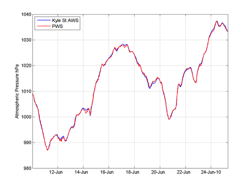
The figure below shows a comparison between the pressure measured by a Fine Offset PWS and a nearby AWS. You can see that the comparison is excellent.
If you find that your sensor is inaccurate, it may be possible to apply a calibration (accessed from configuration menu) within cumulus.
